
|
| About Norfolk | Place Names | Sources | Back |
| A
B C D
E F G
H
I J K
L M N
O P Q
R S T
U V W
X Y Z |
|
On 8 Sep 2010 we received email
from Wayne Jackson of Ottawa recommending the following description of
Goshen (see below). We found Wayne's email interesting and have reproduced
it here:
|
|
Goshen Road -- (contributed by Wayne Jackson) -- runs along the Goshen Ridge east to west from Highway 3 in Middleton Township to Schafer Road in Bayham Township, Elgin County. It passes through the second and third concessions of Middleton Township. It is the most direct route from Courtland to Eden skirting the many deep ravines feeding into Little Otter Creek. The 1877 Historical Atlas of Norfolk says Thomas Connor “…for many years kept hotel at Middleton Centre, at the junction of the Talbot Street and the Goshen Road.” This suggests that the part of Highway 3 running from Goshen Road to Courtland was part of Goshen Road at one time. Everyone who lives along Goshen Road feels that they live in Goshen. There never was a village or corner called Goshen. The Historical Atlas says Goshen Road "runs through the fertile region known as Upper and Lower Goshen, which was settled about 1835 by John McDonnell, Burgess Smith, the Cowans, Stillwells, Mabees and Sandhams. The land in this area is mostly a clay loam." The part west of Mabee’s Side Road is called Upper Goshen, and the part east of Mabee’s Side Road is called Lower Goshen. The Historical Atlas shows two school houses and one church on Goshen Road. There is a Goshen Baptist Church and a Goshen Cemetery. There used to be an East Goshen Public School (S.S. 11 Middleton?) on Goshen Road in front of the Goshen Cemetery. Goshen Road may have derived its name from the Bible as in “Garden of Eden” and “Land of Goshen”. |
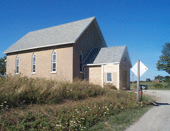
Goshen Baptist Church (taken 9 Aug 2002) see Enlargement 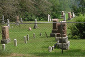 Goshen Cemetery (taken 28 Jul 2008) see Enlargement |
|
Copyright 2010-2012 Wayne Jackson and John Cardiff |